Special Note for Cowichan Watershed Board readers:
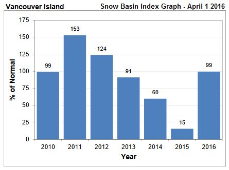 This report from the River Forecast Centre is intended for folks from all regions of British Columbia. But it contains encouraging news for those of us who live on Vancouver Island and particularly, in the Cowichan Watershed: snowpack across Vancouver Island is at about 99% of normal. Compare to last year, when it was about 15% of normal at this time.
This is the first year for the new Heather Mountain Automated Snow Pillow, so there is no historical data which is useful for comparisons. However, the snow pack chart at the left, and the nearby Jump Creek chart shown below give a good sense of the state of Heather Mountain and the Cowichan Watershed Snowpack.
The two charts below, for data up to April 6, 2016, illustrate the situation. Visit our Snowpack page for more information.

With perfect timing, the Cowichan Watershed Board's Speakers Series for April 28 is with David Campbell, Head of the BC River Forecast Centre. He will be speaking about all of this, and much more, beginning at 7:00 pm, at Lecture Room 140 at the VIU Cowichan Campus. Find out more, at our Speakers Series page.
Snow Survey and Water Supply Bulletin – April 1st, 2016
River Forecast Centre, April 1, 2016
The April 1st snow survey is now complete. Data from 146 snow courses and 63 automated snow stations around the province and climate data from Environment Canada have been used to form the basis for the following report.
Click here for the Snow Survey and Water Supply Bulletin as a PDF file.
Click here for the complete April 1, 2016 Snow Survey Data.
Click here for the Basin Snow Water Index Map.
Weather
Temperatures across British Columbia continued to be well above normal through the month of March, with daily temperatures being 1-3╦ÜC above normal through southern BC, and 2ÔÇæ4╦ÜC above normal through the Kootenays, Central, and Northern BC. These warm temperatures have persisted throughout the 2015-16 winter.
March was generally a wet month, with a few heavier storm cycles mixed with drier and unsettled periods with lighter precipitation. A high pressure system with dry and very warm weather dominated the end of the month. Precipitation in March was above normal across most of the province, with typical precipitation amounts in the range of 130-200%. In the Central Interior, precipitation was closer to normal, and the Central Coast, North Coast and North-West were drier than normal.
Snowpack
Despite the warmer weather, wet conditions led to seasonal snow pack growth across most of the province through March. In Northern BC, many basins experienced a drop in basin index values since last month, and in the Okanagan and Boundary, basin index values increased. In general, snow basin indices are near normal (80-120%) across the province, with a provincial average of 91%. Below normal indices (65-80%) are present in the Upper Fraser West, Upper Fraser East, Nechako, and Skeena-Nass, and well below normal (<65%) in the Central Coast, Stikine, North-West, Liard and Skagit. Well above normal snow packs (>120%) are present in the Okanagan. Lower snowpack in the Upper Fraser is offset by slightly higher than normal snow packs in the Thompson River basin, and the overall Fraser River basin index is 96%.
Due to warm weather throughout the winter, low to mid elevation snow packs across the province are greatly diminished this season. While the provincial average for all April 1st surveys is 91% of normal, the average for sites below 1200 m elevation is 62% of normal, and just 44% of normal for sites below 1000m.
Warm weather towards the end of March and in early April has led to the onset of the melt season across the province. All of the provincial automated snow weather stations have recorded melt over the past week, as well as a number of manual surveys which experienced a loss of snow water equivalent between the March 1st and April 1st surveys. The transition from snow accumulation to snow melt is two to three weeks earlier than usual this season.
Table 1: BC Snow Basin Indices – April 1, 2016
| Basin |
% of Normal |
Basin |
% of Normal |
|
Upper Fraser West |
75 |
Okanagan |
131 |
|
Upper Fraser East |
76 |
Boundary |
106 |
|
Nechako |
79 |
Similkameen |
104 |
|
Middle Fraser |
102 |
South Coast |
101 |
|
Lower Fraser |
107 |
Vancouver Island |
99 |
|
North Thompson |
112 |
Central Coast |
59 |
|
South Thompson |
113 |
Skagit |
59 |
|
Nicola |
113 |
Peace |
82 |
|
Fraser River (all) |
96 |
Skeena-Nass |
69 |
|
Upper Columbia |
99 |
Stikine |
57 |
|
West Kootenay |
107 |
Liard |
51 |
|
East Kootenay |
99 |
Northwest |
68 |
Streamflow
With warm temperatures, mid-season melt, and precipitation as rain, most rivers across British Columbia have experienced well above normal streamflow (150% to 200% of median value) over the past several months. Snow melt runoff that typically flows later in the season has already passed through their watersheds. As of early April, virtually all of the rivers in the province were flowing well above normal for the time of year. This advance in runoff timing is expected to continue to lead to an earlier freshet this season, both in terms of timing of peak flows and the recession to the low-flow season.
Outlook
Strong El Niño conditions that developed over the equatorial Pacific regions over the past few months peaked earlier in the winter and are declining. The Climate Prediction Centre (CPC) at the U.S. National Weather Service/NOAA is forecasting a high likelihood of El Niño conditions persisting through until late-spring or early summer 2016.
Seasonal forecasts from Environment Canada are indicating a high likelihood of above-normal temperatures across British Columbia over the April to June period, and an increased chance of warmer than normal temperatures through the extended forecast period into the summer months.
Seasonal volume runoff forecasts (see table below) are near normal for most basins across the province; above normal seasonal runoff (>120%) is forecast for the Nicola River, Similkameen and Okanagan and below normal seasonal runoff (<80%) is forecast for the Cowichan River.
High snow pack in the Okanagan basin indicates elevated seasonal flood risk in the region. Near-normal snow pack elsewhere in the province is an indication of normal seasonal flood risk. Below normal snow packs in the north and west indicate below normal seasonal risk, and watersheds in these areas would need to experience extreme weather conditions to develop flooding conditions this season. With a basin-wide index of 96% for the Fraser River, seasonal risk to lower Fraser River from Hope downstream is normal. The expected peak flow for the Fraser River at Hope is 8000-9000 m3/s; higher or lower flows are possible depending on weather conditions.
The forecast of warmer weather through the spring, combined with warm temperatures already experienced this winter, is likely to be an important factor in this year’s freshet season. With the advanced melt of low to mid-elevation snow that has already occurred, continued warmer than normal temperatures are expected to continue to drive an advance in the freshet season. Typically peak flows in most snow-dominated rivers in the province reach their peak from mid-May through late-June. With the advance in melt already observed, and forecast for ongoing warm weather, the peak season is likely to be advanced to the late-April to early-June period for most rivers in the province.
Current weather forecasts for the next two weeks suggest on-going warm weather. Snow melt rates are expected to increase across the province, as snow packs ripen. River levels are expected to see significant rises over the next few weeks. In the short-term (through mid-April), flows are not expected to reach flood potential level. The River Forecast Centre is modelling streamflow across the province. Information regarding freshet conditions, including hydrologic model forecasts, is available on the Freshet page on the RFC website.
An advanced freshet is expected to put pressure on summer low flows in snow-melt dominated rivers across the province. With very low snow packs in the Central Coast, Skagit, Stikine and Liard, and low snow packs in the Upper Fraser, Nechako, Skeena and Northwest the risk for low flows this summer are elevated. Elsewhere in the province, limited seasonal snow pack at low to mid elevations will also add pressure to low flows later in the season, even in basins with normal snow basin indices.
For both spring flood risk and summer low flows, snow pack is just one of the important elements that determine whether or not extreme conditions will emerge. Weather, through the spring and summer, is also a key driver on whether or not flooding or low stream flows will occur. May and June are climatologically the wet season for the BC Interior. While indicators, like El Niño, have stronger linkages to seasonal temperature, precipitation is difficult to forecast beyond a one to two week horizon. Extreme wet or dry weather can significantly impact risks for peak flows and low flows.
The River Forecast Centre will continue to monitor snow pack conditions and will provide an updated seasonal flood risk and stream flow forecast in the May 1st 2016 bulletin, which is scheduled for release on May 9th.
BC River Forecast Centre
April 7, 2016
Click here for the Snow Survey and Water Supply Bulletin as a PDF file.