WEIR READY
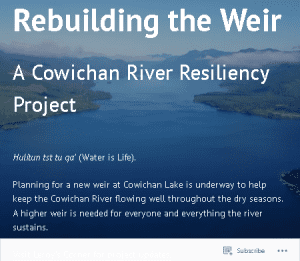
What's the Weir?
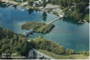 In the 1950’s, a 97 cm high weir was built at Cowichan Lake to store enough water so that Cowichan River flows could be sustained throughout the dry season. "The weir" is actually a series of things, including a pre-existing island, a "rock filled sheet pile dam", a boat lock and several ‘spill gates’, These combine to span the lake at the head of the river. The weir is owned and operated by the Domtar/Catalyst Crofton mill, under license from the BC Government.
With our changing climate, this weir has served a very important function economically and ecologically, and for the well-being of local communities and Indigenous culture. It stores some of the high water in in spring, to gradually let it flow down the Cowichan River at controlled rates from spring to fall. The weir is submerged during high water. It does not exceed natural “high water” levels so natural shorelines and riparian habitats are intact.
What's the Problem?

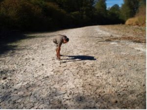
Project 84,000 is a community art initiative to memorialize and mourn the estimated 84,000 fish that died in July 2023, due, in part, to low water flows. Photo by Jennifer Shepherd
Water is essential to all life and the Cowichan River is recognized as a Canadian Heritage River for its extraordinary values. It is central to the spiritual and cultural well-being of BC's largest First Nation by population, Cowichan Tribes. A Cowichan Tribes knowledge keeper recently said "we don't own the river, we belong to the river."
Low river flows effect our collective well-being. Many fish and wildlife species are negatively affected by drought and low river flows. This impacts indigenous cultures that are interconnected with healthy watersheds, and particularly salmon health. Watch our 6 min. "Why Fish Need Water" video here to learn more.
The current weir does not store enough water to maintain recommended river flows due to changes in our climate. In 2023, deadly water quality issues linked to a complex mix of low flows, inadequate sewage dilution, high temperatures, and algae, caused a massive fish die-off in the Cowichan River, eventually estimated to have killed 84,000 steelhead juveniles alone.
Low flows also threaten union jobs at the Crofton mill, which can't run without the water it diverts from the lower river. They can impact drinking water supplies for some. River-based recreation and tourism are very important to the quality of life of citizens and the local economy. There are also impacts for lakeshore residents and ecosystems as lake levels are often lower than usual by late summer or fall, and because fishing is important to the economy and culture of lakeshore communities too.
Cowichan Region, and the watershed, are impacted by longer drier summers due to climate change. In most summers over the past two decades, the river level could not be maintained at ecologically acceptable flows, even above the mill’s water intake pipe in Duncan, because there is not enough water storage in the lake. This means that flows are restricted to below recommended levels to save water for later summer flows. Twice now, the Cowichan River has been run 'on life support' using electric pumps to move water over the lip of the lake to keep the river flowing at all. In 2019 this was necessary for 21 days, and in 2023, pumps were needed for 36 days, until fall rains refill the lake enough to return natural water flows. (Read more here.)
This trend is predicted to worsen. Scientists recently concluded that:
“The Cowichan River is one of the most productive rivers on the eastern side of Vancouver Island and without action it will look radically different by the 2050s. Salmon stocks that utilize the river to spawn and rear during the summer and early fall period will be decimated. Chinook, Coho and Steelhead are particularly vulnerable.” - Source: Cowichan Water Use Plan (2018) www.cowichanwup.ca
 “The Cowichan River is one of the most productive rivers on the eastern side of Vancouver Island and without action it will look radically different by the 2050s. Salmon stocks that utilize the river to spawn and rear during the summer and early fall period will be decimated. Chinook, Coho and Steelhead are particularly vulnerable.” - Source: Cowichan Water Use Plan (2018)
 Cowichan Valley Regional District published Climate Projections for the Cowichan Valley Regional District in 2017. The report provides detailed projections of wetter winters, hotter, drier summers, and an increase in extreme weather events for the 2050s and 2080s.
Cowichan River Needs Urgent Care
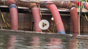
When Cowichan Lake water level drop below the outflow, Catalyst Mill installs electric pumps to move water from Cowichan Lake into Cowichan River to keep the river flowing.
In July 2023, with river flows held at 4.5 cubic meters per second from the Cowichan Lake weir to make the lake water last until fall, an estimated 84,000 steelhead juveniles, plus many other trout, salmon, and other species, died in the upper Cowichan River due to "environmental stress". Read more here.
Later in the summer, 20 electric pumps were needed for 36 days to keep the river flowing even at those inadequate flows, essentially putting one of Canada's Heritage River's on "life support" again. An estimated 20,000 chinook salmon had come back to the river by then, thanks to decades of successful conservation efforts, and were depending on those pumps for their survival. To demonstrate the precariousness of that situation, less than a week after the rains came and alleviated the need for electric pumps to keep them alive, a storm knocked out power in much of Cowichan Region.
What's the Solution?
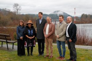
Province supports new weir to keep Cowichan River Flowing. March 22 2024. Cowichan Lake weir shown in background. Photo by Barry Hetschko
Cowichan Tribes, CVRD and Catalyst are working hard as partners to replace the weir to store more of the winter high water for these extended dry spells. Listen to Tom Rutherford's 20 minute "crash course" here, with introductions from elder Philomena Williams, Cowichan Tribes Chief Lydia Hwitsum, and CVRD Chair Aaron Stone. Filmed at the October CWB-VIU Speaker Night. https://www.youtube.com/watch?v=IQfO6plzVYU
In early 2024, with support from the Pacific Salmon Foundation and the participation of all significant fish and water monitoring organizations/agencies in the Cowichan River, two "FishKill" Workshops examined what happened in 2023 together. While the threats of low water flows remain, particularly until the weir is raised, a collaborative monitoring and response plan will reduce the likelihood of a re-occurrence of fish deaths at that scale in the years to come.
To be clear, the massive 2023 fish kill occurred well above the mill's intake pipe, in a year when the mill was closed and not drawing significant water. This reflects the fact that water storage is now needed for ecological conservation purposes in the face of climate change, and this is why the new weir will support a 'conservation water license' as well as maintaining water supply for the mill.
The Watershed Board and our partners are thrilled to announce that as of World Water Day 2024 (March 22) all funding is now in place to replace the weir. The next steps are underway with the Province to establish collaborative governance mechanisms for the conservation water license and the weir.
“People care deeply about our rivers and lakes, which are at the heart of communities like the Cowichan Valley,” said Nathan Cullen, Minister of Water, Land and Resource Stewardship. “I want to recognize the hard work of Cowichan Tribes and their partners in the Cowichan Valley Regional District and Cowichan Water Board for championing a project that will bring significant benefits to the area, such as greater food security, healthy habitat for fish, preserved cultural practice and a water supply that people and businesses can depend on.” (B.C. Media Release, March 22, 2024)
Learn more!
Visit the Weir Project Website

Resources
- Cowichan Lake Water Supply website. https://cowichanlakeweir.ca/
- Cowichan Valley Regional District Climate projections – Climate Change studies specific to Cowichan Region
- Cowichan Tribes fisheries background and history in the watershed (note that the fishing weirs referred to on this page are different from the water storage weir at Cowichan Lake)
- Catalyst Paper – monitoring data and resources for Cowichan water levels and snowpack
- Cowichan Water Use Plan – community interests, studies and consensus recommendation about Cowichan watershed water supplies.
- Cowichan Lake Shoreline Property View Tool.
- Video – Why Fish Need Water.
- Environment Canada Hydrometric data for Cowichan River
- BC Drought portal
5 Local Perspectives
Cowichan Valley residents were interviewed about why they support replacing the weir, published in the Cowichan Valley Citizen, summer 2019.