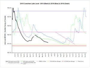
 Various agencies and organizations track water levels on the Cowichan and Koksilah Rivers.For the Cowichan River, Catalyst Paper generates year over year comparison graphs that are helpful to understand lake levels compared to that date in other years. They can be viewed directly here. (See Cowichan Lake Levels and Flow Trend for year over year chart. ) https://www.catalystpaper.com/page/cowichan-water-management-information.
 Or CVRD provides extensive information about water levels throughout the region, including a copy of Catalyst's graph, here. https://cvrdnewnormalcowichan.ca/cowichan-lake-graph/
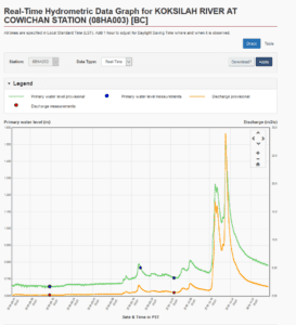
Water levels for both rivers can also be monitored using the hydrometric data tool at Environment Canada's website. Follow the promts and use controls on the website to choose the rivers, dates and other parameters you would like to see.
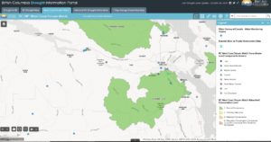 Finally the BC Government's Drought Portal provides additional information. Check West Coast Stream Watch at this website to look up rivers of special concern, including the Koksilah.