In Reflection: A Message from the Co-Chairs As Co-Chairs of the Cowichan Watershed Board, we are pleased to introduce this 2024 Annual Report. It reflects the shared efforts of many hands and hearts working together in service to the Quw’utsun and Xwulqw’selu watersheds. This past year has brought both significant milestones and meaningful reminders of […]
Collaborating for Salmon Resilience From Crisis to Opportunity – a Cowichan Story
Collaborating for Salmon Resilience From Crisis to Opportunity – a Cowichan Story
CWB Target Strategy Discussion Paper – An Evolution
Evolving our Target Strategy – Discussion Paper Draft 2 May 2025 Abstract Shortly after the Cowichan Watershed Board was founded in 2010, it established a series of aspirational “Targets” to communicate its broad goals, engage residents, and keep partners paddling in the same direction for the long trek back to watershed health. These Targets were […]
CWB 2023 Annual Report – Final Draft
Reflections from our Co-Chairs As we reflect on the past year, we are more determined than ever to see all the groundwork we have accomplished on engagement, awareness raising, and planning to move into implementation for the protection of the Cowichan Watershed. With the July 2023 fish die off, the impacts of which will be […]
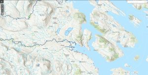
Map of Water Quality Monitoring Locations in the Cowichan and Koksilah Watersheds
- 1
- 2
- 3
- 4
- Next Page »


 Email
Email


