Cowichan Watershed Board

  • Email
  • Facebook
  • RSS
  • YouTube
MENUMENU
  • About
    • Indigenous Co-governance
    • Our Principles
    • Board Members
    • Staff Team
    • Non-Profit Society
    • Supporters (Coming Soon)
    • Contact Us
  • Targets
    • Water Quality
    • Estuary Health
    • Salmon Sustainability
    • Wise Water Use
    • Watershed IQ
    • Water Flows
    • Riparian Plants
    • Target Working Groups
  • Projects
    • River Cleanup
    • Koksilah
    • Twinned Watersheds Project
      • Riparian Plants
      • Indigenous Flows
      • Fish Habitats
      • Big Dancing Fish
    • Weir Ready
      • Weir Ready FAQ
    • Speakers Series
    • Past Projects (Coming Soon)
      • Water Challenge (Coming Soon)
      • Superheroes (Coming Soon)
  • Library
    • Board Meetings
    • Governance Documents
    • Maps
    • Media
    • Presentations
    • Videos
    • Reports
      • CWB Reports
      • Other Reports
    • All Library Items
  • Latest News
You are here: Home / content / Snowpack

Snowpack

December 14, 2014 by Jill Thompson

Precipitation in the Cowichan Watershed in winter has historically been in the form of rain and snow. In higher mountain areas surrounding Cowichan Lake, the snowpack that builds through the winter is a reservoir of water that augments the capacity of the lake, and contributes significantly and critically to the lake in spring and summer.

Snowpack throughout the province is monitored by the River Forecast Centre of the Ministry of Environment and Climate Change Strategy. Automatic Snow Pillow Stations (ASPs) and manual inspections are both used. This is a description of an ASP from the River Forecast Centre:

Our British Columbia snow pillows consist of 3 metre diameter bladders containing antifreeze solution. As snow accumulates on the pillow, the weight of the snow pushes an equal weight of the antifreeze solution from the pillow up a standpipe in the instrument house. This weight of the water content of the snow is termed Snow Water Equivalent (SWE). The distance the antifreeze is pushed up the standpipe is recorded by a float connected to a shaft encoder. (from What Is An Automatic Snow Weather Station?)

The Cowichan Watershed's first ASP was installed in 2015 on Heather Mountain (3B24P – Heather Mountain Upper) at 1190 m elevation (a little more than 1000 m above Cowichan Lake), replacing two manual station on Heather Mtn. It joins the Jump Creek ASP in the Nanaimo Watershed at 1134 m, adjacent to the Cowichan on the north, which has served as a proxy for a Cowichan Watershed ASP prior to the commissioning of Heather Mtn.

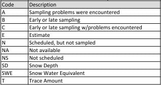
This table summarizes the snowpack data in 2016-17, 2017-18, and to January 1 2019, and compares those years to the 20 year history available for Jump Creek. The manual Heather Mtn. data was not included in this summary. Click here to decode the abbreviations in the table.

The River Forecast Centre issues reports effective to the first of each month from January to June, with additional reports on May 15 and June 15. Click here for Snow Conditions & Water Supply Bulletins.

The Jump Creek chart at the bottom demonstrates how much the snowpack in recent years is reduced from the long term average. The Heather Mtn. chart, immediately below, is still made up of little historical data, unlike Jump Creek. The different scales on the two charts can also mislead so keep this in mind when comparing the two.

3B24P – HEATHER MOUNTAIN UPPER

Heather Mountain Upper Snow Pillow
 

3B24P – HEATHER MOUNTAIN UPPER

3B23P – JUMP CREEK

Jump Creek Snow Pillow

3B23P – JUMP CREEK

For more information

River Forecast Centre, Ministry of Environment and Climate Change Strategy

Filed Under: content

Click image for more information

2023 RiverCleanup Poster

Click for more information

Click image for Board Meeting Agenda Packages

2023 CWB Members

2023 Cowichan Watershed Board members. Click image for Board Meeting Agenda Packages

Cowichan Lake Weir Updates (Click image)

Final Design Concept image

Cowichan Lake Weir Updates (Click image)

Why Fish Need Water

Latest News

  • Changing Conditions Force Difficult Decisions for Managing Cowichan River
  • Workers to pump water into Cowichan River amid drought
  • CBC Radio – On The Island Interview with Tom Rutherford -Cowichan River water levels.
  • Prolonged drought, low flows behind mass fish kill on Cowichan River, says DFO

Sign up for E-News!

Board Meeting Notifications

Event Notifications

CWB Website

Home
About Us
Contact
Cowichan Basin Water Management Plan
Documents & Presentations
Privacy
Terms

Targets

Water Quality
Estuarine Health
Salmon Sustainability
Water Use
Watershed IQ
Water Supply
Riparian Area Protection

Cowichan Watershed

Introduction
Cowichan Lake
Quamichan & Somenos Lakes
Cowichan Estuary
The Weir

Logo Email

info@cowichanwatershedboard.ca

Mailing Address
4335 Riverside Road
Duncan, BC, V9L 6M8

Copyright © 2023 Cowichan Watershed Board - All Rights Reserved. | Design by MAC5

sponsor logo
The Cowichan Watershed Board (CWB) gratefully acknowledges the financial support of the above organizations.