Image from Water Quality Div. Wake County NC
A watershed is an area of land that is drained by rivers and their tributaries into bodies of water – ponds, lakes, and ultimately, and in the case of the Cowichan Watershed, into the ocean.
Think about the Cowichan Watershed, or your local creek, river or stream. Where does it start? What types of landscapes does it pass through and where does it end up? All of the area covered is a watershed.
A watershed is made up of a unique mix of habitats that influence each other. These habitats include alpine areas, forests, wetlands, fields and meadows, rivers and lakes, farms and cities and towns. In the case of the Cowichan, it all comes together in the Cowichan Estuary.
Most watersheds of any size are made up of smaller watersheds, or catchment areas. Quamichan Lake is at the centre of the Quamichan Watershed. It is also a part of the Cowichan Watershed. Of course, Cowichan Lake and Cowichan River are the defining hydrological features of the Cowichan Watershed.
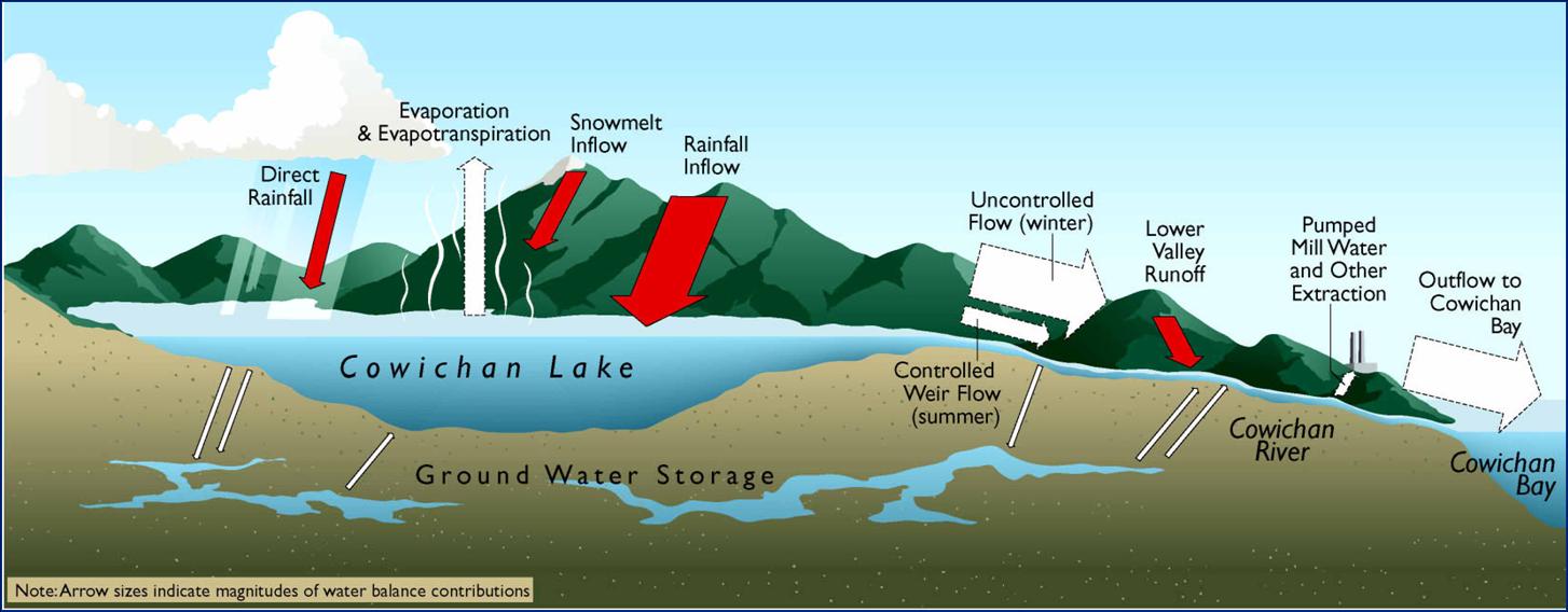
A watershed is not just the visible surface features, either – it is much more than that. A high percentage of the water that originates in the watershed as precipitation – rain and snow – is retained as groundwater. 95% of the fresh water in the world is retained as groundwater. Groundwater moves more slowly than surface runoff, but it is in motion. Moving even more slowly is groundwater contained in aquifers, underground areas covered by low-porosity caps.

Aquifer map of the Cowichan Watershed
The hydrological communication is complex and dynamic between water on the surface – in streams and lakes, groundwater, and aquifers. It is understood in principle, but data collection and mapping of subsurface hydrological features and vectors is far from adequate in BC. The groundwater features of the lower Cowichan Watershed are reasonably well mapped, however.
Aquifers tend to  be repositories of high-quality water, consequently, they are the target of domestic, municipal, and agricultural wells. With modest demand, aquifers will recharge seasonally. With growing demand and reduced precipitation, BC’s aquifers have become stressed.
Population growth in all regions, including Cowichan, results in an increasing demand for water, particularly in summer. Exacerbated by the reduced summer precipitation which is one of the manifestations of climate change, the Cowichan River, and the groundwater in the lower Cowichan Watershed are experiencing demand for more water than they can deliver in late summer.
Related Reading
Water, Environment Canada
The Water Cycle, US Geological Service