Cowichan Watershed Board

  • Email
  • Facebook
  • RSS
  • YouTube
MENUMENU
  • About
    • Indigenous Co-governance
    • Our Principles
    • Board Members
    • Staff Team
    • Non-Profit Society
    • Supporters (Coming Soon)
    • Contact Us
  • Targets
    • Water Quality
    • Estuary Health
    • Salmon Sustainability
    • Wise Water Use
    • Watershed IQ
    • Water Flows
    • Riparian Plants
    • Target Working Groups
  • Projects
    • River Cleanup
    • Koksilah
    • Twinned Watersheds Project
      • Riparian Plants
      • Indigenous Flows
      • Fish Habitats
      • Big Dancing Fish
    • Weir Ready
      • Weir Ready FAQ
    • Speakers Series
    • Past Projects (Coming Soon)
      • Water Challenge (Coming Soon)
      • Superheroes (Coming Soon)
  • Library
    • Board Meetings
    • Governance Documents
    • Maps
    • Media
    • Presentations
    • Videos
    • Reports
      • CWB Reports
      • Other Reports
    • All Library Items
  • Latest News
You are here: Home / content / Cowichan Lake Level

Cowichan Lake Level

March 14, 2019 by Jill Thompson

This chart shows the water level in Cowichan Lake for the previous 18 months. It is usually kept up-to-date to yesterday.

The chart comes from the Water Survey of Canada which maintains five automated stations within the Cowichan Watershed. The Cowichan Watershed Board provides a portal to the WSC on the Discharge Charts page.

This chart has four main areas, which are described here:

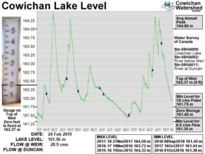
In the centre, is the 18 month chart showing the seasonal rise and fall of Cowichan Lake. The line is made up of the daily average of measurements from the automated station. The level is given in metres above sea level. 162.37 metres is the top of the weir.

On the left, is a photo of the gauge mounted on the weir. It uses the Imperial scale in feet, with the zero at 162.37 metres above sea level.

On the right, are five significant levels that are of concern in the annual management cycle of the lake and the river flow. Also on the right are the names of the three water gauges displayed on this chart: the lake where we care concerned with water level, the river directly below the weir, and the river near Duncan.

On the bottom, are the most recent metrics, as well as peak highs and lows for the last three seasons.

Filed Under: content

Click image for more information

2023 RiverCleanup Poster

Click for more information

Click image for Board Meeting Agenda Packages

2023 CWB Members

2023 Cowichan Watershed Board members. Click image for Board Meeting Agenda Packages

Cowichan Lake Weir Updates (Click image)

Final Design Concept image

Cowichan Lake Weir Updates (Click image)

Why Fish Need Water

Latest News

  • Changing Conditions Force Difficult Decisions for Managing Cowichan River
  • Workers to pump water into Cowichan River amid drought
  • CBC Radio – On The Island Interview with Tom Rutherford -Cowichan River water levels.
  • Prolonged drought, low flows behind mass fish kill on Cowichan River, says DFO

Sign up for E-News!

Board Meeting Notifications

Event Notifications

CWB Website

Home
About Us
Contact
Cowichan Basin Water Management Plan
Documents & Presentations
Privacy
Terms

Targets

Water Quality
Estuarine Health
Salmon Sustainability
Water Use
Watershed IQ
Water Supply
Riparian Area Protection

Cowichan Watershed

Introduction
Cowichan Lake
Quamichan & Somenos Lakes
Cowichan Estuary
The Weir

Logo Email

info@cowichanwatershedboard.ca

Mailing Address
4335 Riverside Road
Duncan, BC, V9L 6M8

Copyright © 2023 Cowichan Watershed Board - All Rights Reserved. | Design by MAC5

sponsor logo
The Cowichan Watershed Board (CWB) gratefully acknowledges the financial support of the above organizations.