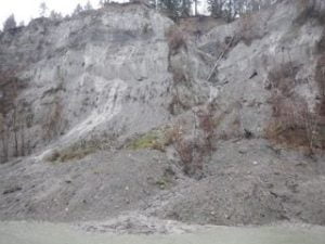
James Craig, BC Conservation Foundation, December 12 2014 This short video illustrates the type of landslide that can result on slopes that saturated as a result of heavy rainfall, and which are not stabilized by vegetation. In this instance, significant engineering and reconstruction at Stoltz Bluff a few years ago, included catchment ponds areas to […]
Landslide at Stoltz Bluff following heavy rainfall
Cowichan Lake West Bathymetric Map
Cowichan Lake East Bathymetric Map

Cowichan Lake (1:50,000)
Large file: 34 mb
- « Previous Page
- 1
- …
- 79
- 80
- 81
- 82
- 83
- …
- 143
- Next Page »