 The lower slopes and floodplain of the Cowichan – Koksilah river system contain significant areas of agricultural land as well as rural, urban and industrial development. Dikes have been built along both banks of the Cowichan River to protect the developed urban core of the City of Duncan and the extensive agricultural and industrialized zones downstream. Dikes have also been constructed on lands of the Cowichan Tribes at various tiines including along the Koksilah River.
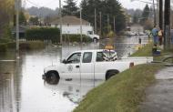
The valley has experienced many flood events resulting from high flows in the Cowichan River and its tributaries, and from ponding in low-lying areas during heavy rain events. Large flow events in the Cowichan River were documented in 1979, 1986, 2007, and 2009.
 The flood management area extends along the Cowichan River from below the Catalyst water intake down to the ocean and along the Koksilah River from just below Bright Angel Park down to the ocean. Also included are Somenos Creek and Somenos Lake.
In 2009, the Cowichan Valley Regional District commissioned Northwest Hydraulic Consultants to develop an Integrated Flood Management Plan. Conclusions from extensive studies indicated that none of the existing dykes have adequate freeboard for a 200-year flood event, and reported a number of other probabilities of high concern.
Coincident with the release of the Integrated Flood Management Plan, were the November 2009 and January 2010 floods.
 In June 2010, a three-phase federal – provincial infrastructure aid program was announced, which will enable the CVRD and Cowichan Tribes to implement some parts of the flood management plan.
The final report from the Integrated Flood Management Plan was presented to the CVRD's Regional Services Committee in May 2010. Click here to download the agenda package, including the Executive Summary, Conclusions, Table of Contents, and Map.
A summary of the Integrated Flood Management Plan was presented at the September 2010 meeting of the Cowichan Watershed Board. Click here to view presentation. In addition a number of flood related issues were discussed on the Board and TAC's November 6, 2010 field trip.
Related Documents
Integrated Flood Management Project Applications, Presentation, September 2010
Lower Cowichan/Koksilah River Integrated Flood Management Plan – FinalReport
Northwest Hydraulic Consultants, September 2009
Contact the CVRD at 250-746-2500, or use its online form.
Map – Tier II and Tier III Priority Projects
Northwest Hydraulic Consultants, August 2009
 Email
Email


