Cowichan Watershed Board

  • Email
  • Facebook
  • RSS
MENUMENU
  • About
    • Our Principles
    • Cowichan Watershed Board
    • Cowichan Watershed Society
    • About Cowichan & Koksilah
    • Partnership
  • Issues & Targets
    • Water Quality Target
    • Estuary Health Target
    • Salmon Sustainability Target
    • Water Use Target
    • Watershed IQ Target
    • Water Supply Target
    • Riparian Target
  • Resources
    • Meetings
    • CWB News Releases
    • Documents & Presentations
    • Water Level Graphs
  • News & Events
    • Meetings
    • Speakers Series
    • CWB News Releases
  • Contact Us!
    • Sign Up for E-News
You are here: Home / content / The Cowichan Lake Weir

The Cowichan Lake Weir

October 4, 2010 by Manager

CowichanLakeWeir-labelled
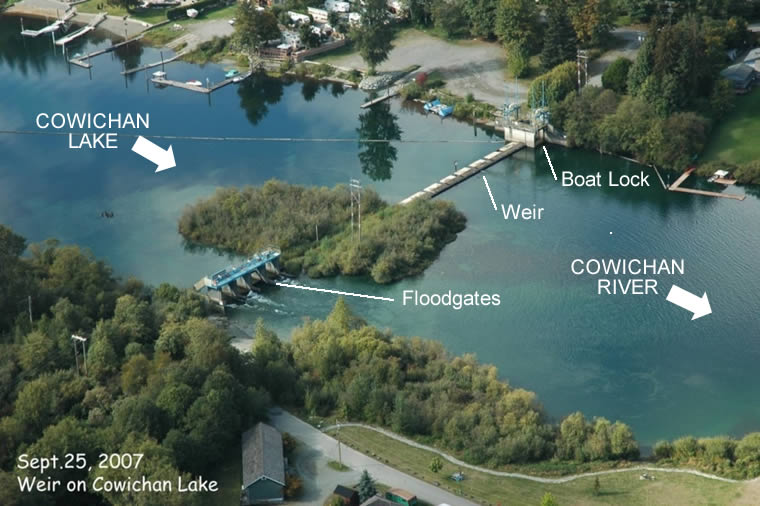
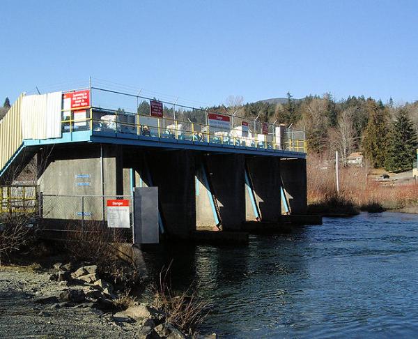
The weir on Cowichan Lake is used to control the outflow from the lake into the Cowichan River. For much of the time between late fall and late spring each year, it does nothing, and the weir is referred to as “off control” – since the lake level is above the top of the weir. For most of the rest of the year the weir is normally functional.

Its job is to balance two objectives:

1. to maintain a flow rate, or discharge rate, in the river above 7 cubic metres per second (m3/s), and

2. to maintain sufficient water in the lake as long as possible.

WeirControlGatesIn the later summer – early fall period, the two goals cannot both be be met in most years. Management of the weir becomes a challenging judgement call in which the lake level, discharge rate in the river, salmon priorities, and rainfall predictions are all factors which must be juggled.

In low water years, the lake level may actually drop below the level at which the weir comes into play. This situation, which was common before the weir was built in 1957, is avoided if possible, in order to ensure that some water is left to provide “pulse” charges into the river which will trigger migrating salmon, who are swarming in Cowichan Bay, to start moving up the river.

The shifting decision-making is guided by a “rule curve” which was established some years ago to help with this process. The inflexibility of the rule curve has led to a proposal to modify the curve to a “rule band”. The provincial government has yet to consent to implementation of the rule band.

Physically, the weir is roughly 1 metre tall. It was built in 1957 and is managed by Catalyst Paper, owners of the Crofton Mill.

Late summer-early fall conditions in recent years – low water, and low precipitation even into November – resulted in the Cowichan Management Plan recommendation that changes to the weir, including raising it almost a metre, should be seriously considered.  A consequence is “potential effects on lakeshore properties due to significantly increased water levels during weir operation.” 

In 2014, the CVRD passed a resolution in support of the Plan’s “recommendation to store and/or access sufficient  spring  runoff  in Cowichan Lake to sustain river flows during summer and fall.”

Lake level and the role of the weir in winter, summer, and fall
WeirInWinter

In winter, the lake level is above the crest of the weir. The “control point” is at the Greendale trestle, about 300 metres downstream.
(Click any image for a larger version)

WeirInSummer

As summer advances, the lake level is kept at the crest of the weir and then starts to drop according to the rule curve. The “control point” is the floodgates on the weir.

WeirInFall

By fall, the lake level is at its lowest, and the weir floodgates may be fully opened. The “control point” now shifts roughly 1500 m downstream to the Greendale Trestle.


Related Resources

Cowichan Basin Water Management Plan
Westland Resource Group, March 2007

Cowichan Weir Operating Guidelines
Michelle Vessey et al, Catalyst Paper, October 2008

Summer Lake and River Level 2010: What’s Happening?
Craig Sutherland, Presentation, July 2010

Cowichan Lake Water Management Rule Curve & Rule Band
Craig Sutherland, Presentation, January 2011

Cowichan Lake Weir Operation – Rule Curve & Rule Band
Craig Sutherland, Report, January 2011

Filed Under: content

Search Website

Join Us on Facebook

3 days ago
No Freighter Anchorages

This video explains the whole anchorage mess in a simple way.

If it inspires you, take action here:
https://nofreighteranchorages.ca/take-action-now/

View on facebook
1 week ago
cowichanwatershedboard.ca

Regarding the proposed expansion of the Vancouver Island Motor Circuit facility on Highway 18: In August, the Watershed Board was asked by the Municipality of North Cowichan to review the available documentation at that time and provide input. That is available on our website here for anyone interested. https://cowichanwatershedboard.ca/wp-content/uploads/2019/09/CWB-Comments-VIMC-Referal-Final-as-approved-by-CWB-30.09.19.pdf ... See more

View on facebook
1 week ago
Cowichan Watershed Board

Watch out Suckers! Cowichan Lake Lamprey Speaker Night with Joy Wade. Photos courtesy of Genevieve Singleton

View on facebook
« ‹ 1 of 14 › »

Cowichan Lake Water Levels

Click Chart to View.
Graph by Catalyst Crofton based on Water Survey of Canada data.
 
Sign up for E News

CWB Website

Home
About Us
Contact
Cowichan Basin Water Management Plan
Documents & Presentations
Privacy
Terms

Targets

Water Quality
Estuarine Health
Salmon Sustainability
Water Use
Watershed IQ
Water Supply
Riparian Area Protection

Cowichan Watershed

Introduction
Cowichan Lake
Quamichan & Somenos Lakes
Cowichan Estuary
The Weir

Cowichan Watershed Board
info@cowichanwatershedboard.ca
4335 Riverside Road
Duncan, BC, V9L 6M8

Copyright © 2019 Cowichan Watershed Board - All Rights Reserved. | Design by MAC5

The Cowichan Watershed Board (CWB) gratefully acknowledges the financial support of the above organizations.